|
|
List of
Banks in the Caribbean
List of Banks in Sint Eustatius
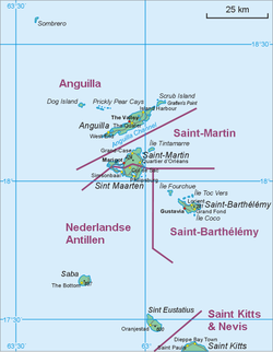
Sint Eustatius, also known affectionately
to the locals as Statia or Statius, is one of the islands that make up
the Netherlands Antilles; it is in the northern, Leeward Islands portion
of the West Indies, southeast of the Virgin Islands.
Sint Eustatius is part of the inner arc of the Leeward Island chain,
lying immediately to the northwest of Saint Kitts and Nevis and to the
southeast of Saba, at 17°30′N 62°58′W / 17.5°N 62.967°W / 17.5;
-62.967. The island is named after the legendary Christian martyr Saint
Eustace. The regional capital is Oranjestad.
Sint Eustatius has a land area of 21 km² (8.1 sq. miles). At the 2001
Netherlands Antilles census, the population was 2,292 inhabitants,
equating to a population density of 109 inhabitants per square
kilometre. In 2004, the population was estimated at 2,498 inhabitants.
The official languages are Dutch, English and Papiamento. A local
English-based creole is also spoken informally. Travel to the island by
air is through F.D. Roosevelt Airport.
Sint Eustatius is slated to become a special municipality within the
Kingdom of the Netherlands on October 10, 2010.
The University of Sint Eustatius, School of Medicine is located on the
island with students coming predominantly from the United States and
Canada, but also from many other international locations. The students
of the university of Sint Eustatius School of Medicine provide an
important source of revenue for the island and local economy, bringing
in tens of thousands of dollars every semester for food, accommodations
and more.
FirstCaribbean International Bank Ltd.
Address: Emmaweg
Phone: (599) 318-2392
Fax: (599) 318-2734
The Windward Island Bank Ltd.
Address: Mazinga Mall
Phone: (599) 318-2846 / (599) 318-2847
Fax: (599) 318-2850
History
Sint Eustatius harborThe island was seen by Christopher Columbus in 1493
and claimed by many different nations over the course of the next 150
years. In 1636, it was colonized by the chamber of Zeeland, and as of
1678, the islands of Sint Eustatius, Sint Maarten and Saba fell under
direct command of the Dutch West India Company, with a commander
stationed on Sint Eustatius to govern all three. At the time, the island
was of some importance for sugar cultivation.
In the 18th century, Sint Estatius's geographical placement – at the
fulcrum between the Leeward and Windward Islands of the Lesser Antilles,
in the middle of Danish (Virgin Islands), English (Jamaica, St. Kitts,
Barbados, Antigua), French (Ste. Lucie, Martinique, Guadeloupe) and
Spanish (Cuba, Puerto Rico, Hispaniola) territories – its large
harborage, neutrality and status from 1756 as a free port with no
customs dutues were all factors in it becoming a major point of
transhipment of goods, and a locus for trade in contraband. The
island was known as The Golden Rock and its economy flourished by
ignoring the trade embargoes between the great powers.
Edmund Burke said of the island in 1781:
It has no produce, no fortifications for its defense, nor martial spirit
nor military regulations ... Its utility was its defense. The
universality of its use, the neutrality of its nature was its security
and its safeguard. Its proprietors had, in the spirit of commerce, made
it an emporium for all the world. ... Its wealthy was prodigious,
arising from its industry and the nature of its commerce.
Johannes de Graaff[edit] "First Salute"
Since the island sold arms and ammunition to anyone willing to pay, it
was one of the few places from which the rebellious Thirteen colonies
could obtain weaponry. This good relationship between Sint Eustatius and
the United States resulted in the noted "First Salute" of 16 November
1776, when Commander Johannes de Graaff of Sint Eustatius decided to
return the salute fire of the visiting American brigantine Andrew Doria
by firing the cannons of Fort Oranje, the first international
acknowledgment of the independence of the United States. The gesture
provided the title for Barbara W. Tuchman's 1988 book The First Salute:
A View of the American Revolution.
The British took the incident seriously, and protested against the
continuous trade between the United States and Sint Eustatius. In 1778,
Lord Stormont claimed in Parliament that, "if Sint Eustatius had sunk
into the sea three years before, the United Kingdom would already have
dealt with George Washington". The trade between Sint Eustatius and the
United States was the main reason for the Fourth Anglo-Dutch War, which
was disastrous for the Dutch economy.
As a result of the war, Sint Eustatius was taken by British Admiral
George Brydges Rodney on 3 February 1781. Commander De Graaff, who at
the time did not know about the declaration of war, saw that he was
facing superior forces, and surrendered the island after firing two
rounds as a show of resistance for the honor of Dutch Admiral Lodewijk
van Bylandt, who commanded ships of the Dutch Navy which were in the
harbor. Ten months later, the island was conquered by the French,
allies of the Dutch in this war. The Dutch regained command over the
island in 1784.
At its peak, Sint Eustatius may have had a population of about 10,000
people, but over time it was eclipsed by other Dutch ports, such as
those on the islands of Curaçao and Sint Maarten, and the population
gradually declined.
Jewish population
The island was home to a Jewish settlement, mainly merchants and
plantation owners. Within a day of the island being surrendered to the
British in 1781, part of the Jewish community – all the men and governor
de Graaff – were forcibly deported to England. The Honen Dalim
Synagogue, built in 1739 and burned by Admiral Rodney in 1781, stood in
ruins until 2001, when its walls were restored as part of the Historic
Core Restoration Project. Now funds are being sought from private donors
to construct a modern roof on the ancient ruins. There are no images
showing what the synagogue looked like when it was in use, therefore a
proper 'restoration' of the structure to its former condition is not
possible.
View of the Quill[edit] Geography
Geographically, the island is saddle-shaped, with the 602 meter-high
dormant volcano Quill, (from Dutch kuil, meaning 'pit' - because of its
crater) to the southeast and the smaller pair Signal Hill/Little
Mountain (or Bergje) and Boven Mountain to the northwest. The Quill
crater is a popular tourist attraction on the island. The bulk of the
island's population lives in the "dip" between the two areas, which
crosses the center of the island.
The Great Hurricane of 1780 caused cataclysmic damage and the loss of
over 4,000 lives on Sint Eustatius.
The national parks of Sint Eustatius, comprising the Quill, the
Botanical Garden, and the Marine Park, are all under the control of the
non profit foundation STENAPA.
Get your own Bank account with ATM card
(Maestro/Mastercard debit card) for withdrawals with a Bank in the Caribe
|